Southern California Wildfires, 2007
Witch - Guajito - Poomacha Complex
Harris, Horno, Rice Canyon, Coronado Hills and McCoy Fires
Los Angeles, Riverside and Ventura Fires
Witch - Guajito - Poomacha Complex
Harris, Horno, Rice Canyon, Coronado Hills and McCoy Fires
Los Angeles, Riverside and Ventura Fires
GOES satellite-based movie and still images
showing path and extent of smoke blown over the Pacific by Santa Ana winds
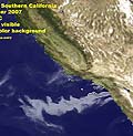
showing path and extent of smoke blown over the Pacific by Santa Ana winds

B&W movie of smoke Date Oct 21 - Oct 25, 2007 Format .mov [3.7 MB] Comment Shows smoke blowing in direction of offshore Santa Ana winds, change in wind direction and end of Santa Ana event Source GOES Project Goddard Space Flight Center, NASA |

Color movie of smoke Date Oct 21 - Oct 26, 2007 Format .mov [2.2 MB] Comment Shows smoke blowing in direction of offshore Santa Ana winds, change in wind direction and end of Santa Ana event Source GOES Project Goddard Space Flight Center, NASA |

Still image of smoke Date Oct 22, 2007 Format .jpg [154 KB] Comment Shows smoke blowing in direction of offshore Santa Ana winds Source GOES Project Goddard Space Flight Center, NASA |
|
|
|
GOES Project
A "scrapbook of all the GOES weather satellite pictures collected by the GOES Project Scientist at NASA since 1994." Goddard Space Flight Center, NASA |
©2007 by the Earthguide at the University of California San Diego.
All rights reserved.
Last modifed Friday, November 2, 2007